

Synthetic Aperture Radar Development in Multimedia University
Radar is the abbreviation for “Radio Detection and Ranging”. It operates by radiating electromagnetic energy through a transmitting antenna and detecting the reflected or scattered signal from the target. Synthetic Aperture Radar (SAR) is an imaging radar which utilizes relative motion between an antenna and the target under observation to synthesize a very long antenna via signal processing. As compared to the conventional real aperture radar, SAR can obtain finer spatial resolution particularly in azimuth direction. The concept of SAR can be traced back to early 1950s when Carl Wiley proposed a Doppler beam sharpening system to improve the azimuth resolution of radar. Today, SAR has become an important tool for microwave remote sensing because of its capability to operate day and night, and in nearly all weather conditions. It has wide range of applications, including sea and ice monitoring, mining, oil pollution monitoring, oceanography, snow monitoring, terrain classification and so on. The potential of SAR in a diverse range of applications has led to the development of a number of airborne and spaceborne SAR systems.
SAR imaging has the advantages of all-weather imaging. It will not constraint by clouds, haze, rain, snow and other weather conditions. With the right choice of radar wavelength, it is able to penetrate through the surface of the target. This unique feature has been extensively used in both civilian and modern military fields for scientific and target reconnaissance purposes. Besides provides terrain information, SAR imaging can also provide other useful information on the ground. Different objects have different physical and chemical properties such as dielectric constant and surface roughness. Microwave frequencies, look angle and polarization used will affected targets’ scattering properties and penetration level. Extra information obtain will enhance the effectiveness of classification and identification of the targets. With interferometric capability, SAR images can generate 3D image as well, and this enable high measurement capability using SAR technique.
In late 2008, a new UAVSAR project was initiated at Centre of Remote Sensing & Surveillance Technologies (CRSST), Multimedia University (MMU), Malaysia, in collaboration with Agency Remote Sensing of Malaysia (ARSM). This project was started after preparatory studies in the previous year. The proposed system is a C-band, VV-polarization, miniature SAR mounted on a small UAV. The UAVSAR system is designed to operate at low altitudes with low transmit power in order to optimize the operating cost. The construction of the SAR sensor was completed in early 2010. A series of indoor and outdoor testing and measurements has been carried out to verify the performance of the system. At the end of 2010, flight missions have been conducted at Mersing, Johor. High quality SAR images were obtained which demonstrated the capabilities of the UAVSAR for remote sensing applications in Malaysia.
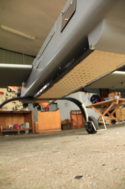
Figure 3: The SAR Antenna Mounted at the Bottom of the UAV’s Fuselage
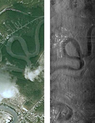
Figure 4: (a) Google Earth Map (b) SAR Image-1 at Mersing Site
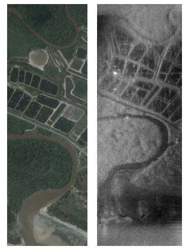
Figure 5 : (a) Google Earth Map (b) SAR Image-2 at Mersing Site
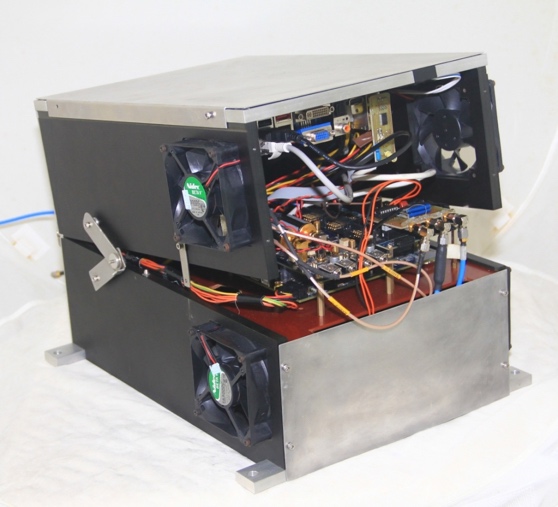
Figure 1: SAR Sensor Developed by CRSST, MMU Melaka
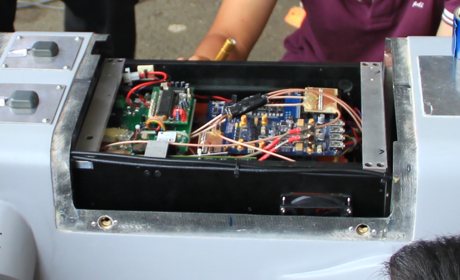
Figure 2: The SAR Sensor Mounted Inside the UAV Compartment
Recently, CRSST has started the development of a ground-based synthetic aperture radar (GBSAR) for continuous monitoring of landslide-prone areas in Malaysia as landslide is the most commonly seen land deformation issues for the past few years in Malaysia. It is an ultra-wideband system operating at K-band with spatial resolution of 0.5 m in range and 5.8 mrad in cross range. The system is mounted on a rail which travels along a linear guide to achieve SAR imaging. The GBSAR have been installed at Gunung Pass, Cameron Highland and at a permanent test site in MMU Melaka to perform long terms field measurement for performance verification and land deformation monitoring purposes. The photo of GBSAR is shown in the figure below.
Preliminary testing of the GBSAR have been conducted in Cameron Highland, Malaysia in order to verify the performance of the GBSAR and the capability of detecting landslide. Figure 6 (a) and (b) show the housing built by JKR for GBSAR testing and GBSAR installed in JKR housing respectively. The photo of the observation are is shown in Figure 4 (c) and external artificial target (trihedral) is shown in Figure 4 (d). The trihedral is used to confirm the correct detection of the test site.
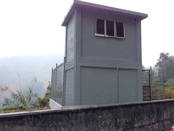
Figure 6: (a) Housing Built by JKR for GBSAR testing
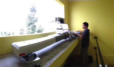
Figure 6: (b) GBSAR installed in JKR Housing
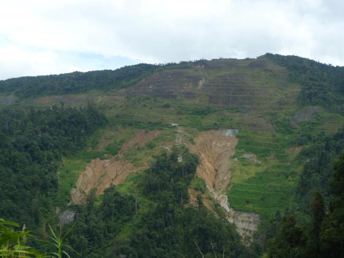
Figure 6: (c) Field Measurement Test Site at Cameron Highland, Malaysia
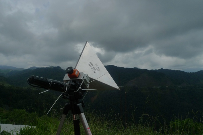
Figure 6: (d) Trihedral Corner Reflector as external target
This figure shows the comparison between the SAR image generated and the google map image (optical). Both show the similar terrain features in the images.
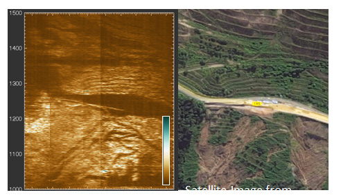
Figure 7: SAR image (left) generated compares to Google map image (right)
Besides, the trihedral corner reflector is adjusted with 0.5mm step to simulate the changes of the terrain. A series of scanning was performed with different step size of trihedral. Figure 8 shows the measurement results whereby the y-axis is the measured displacement based on the phase change of the received signal and x-axis corresponded to the displacement position of the trihedral in which each position is equivalent to 0.5mm of the changes.
The GBSAR system for land deformation monitoring has been successfully developed for land deformation monitoring. A series of field measurement has been conducted and the preliminary results show that GBSAR has a great potential to perform the disaster monitoring such as landslide monitoring. This system is currently installed in MMU Melaka campus for long term data collection.
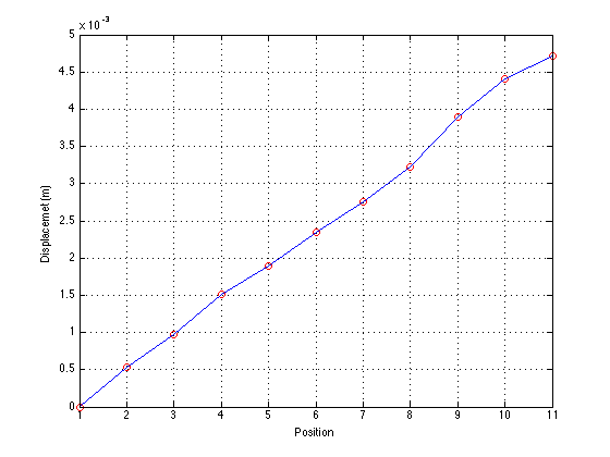
Figure 8: Measured displacement of 0.5mm per step

Ir. Dr. Chan Yee Kit is an Associate Professor and Chairman for Centre of Remote Sensing and Surveillance Technologies, Multimedia University. His research interest includes synthetic aperture radar design, microwave remote sensing, radar sensor development and RF system design. He has been a principal consultant for various government agencies and engineering firms since 2000. He has published more than 80 international journal and conference papers. He was awarded the Senior Membership of Institute of Electrical and Electronics Engineers (IEEE), USA in year 2006. He is a registered Professional Engineer with Board of Engineer Malaysia since 2010. He is also the corporate member of Institute of Engineer Malaysia, Professional Member of Institution of Geospatial and Remote Sensing Malaysia, as well as Professional Technologist for Malaysia Board of Technologist. Besides, he is also actively participating in voluntary services and serve as National Hon. Treasurer for St. John Ambulans of Malaysia.