

4 Potential Threats of our Residential Environment
TODAY, about 55% of the world’s population lives in urban areas and it is projected that urban population will increase to 70% by 2050. The environment is an important factor in determining the quality of life and health of urban dwellers. A good quality of the urban environment will make it more attractive and healthier to live, work and invest in. On the other hand, the degradation of the environment, through air pollution, poor road traffic and climate change, may have negative impacts on human health and well-being.
Here, we will discuss 4 major environmental threats that have direct impact to urban dwellers.
A. Global Warming
Global warming is the increase of Earth’s average surface temperature due to the emission of greenhouse gases such as carbon dioxide from burning fossil fuels or from deforestation, which trap heat that would otherwise escape from Earth. The following graph illustrates the change in global surface temperature relative to 1951-1980 average temperatures. The year 2016 marks as the warmest on record and the year 2017 is ranked as the second warmest since 1880, according to an analysis by NASA (NOAA Global Climate Report, 2018).
Heat waves and warming temperatures pose a serious threat for human settlements worldwide, especially in urban environments. This is because modern cities are densely packed with buildings, and they are lack of green space and vegetation, which limits shading and evapotranspiration. Research shows that the increase in temperature or heat burden may cause heat-related illness such as heat stroke, heat syncope, heat exhaustion, and heat cramps. For every 1 F (0.6 °C) increase in heat wave intensity, there is a 2.49% increase in risk of death. Furthermore, every one-day increase in heat wave duration results in a 0.38% increase in mortality risk (Anderson & Bell, 2011).
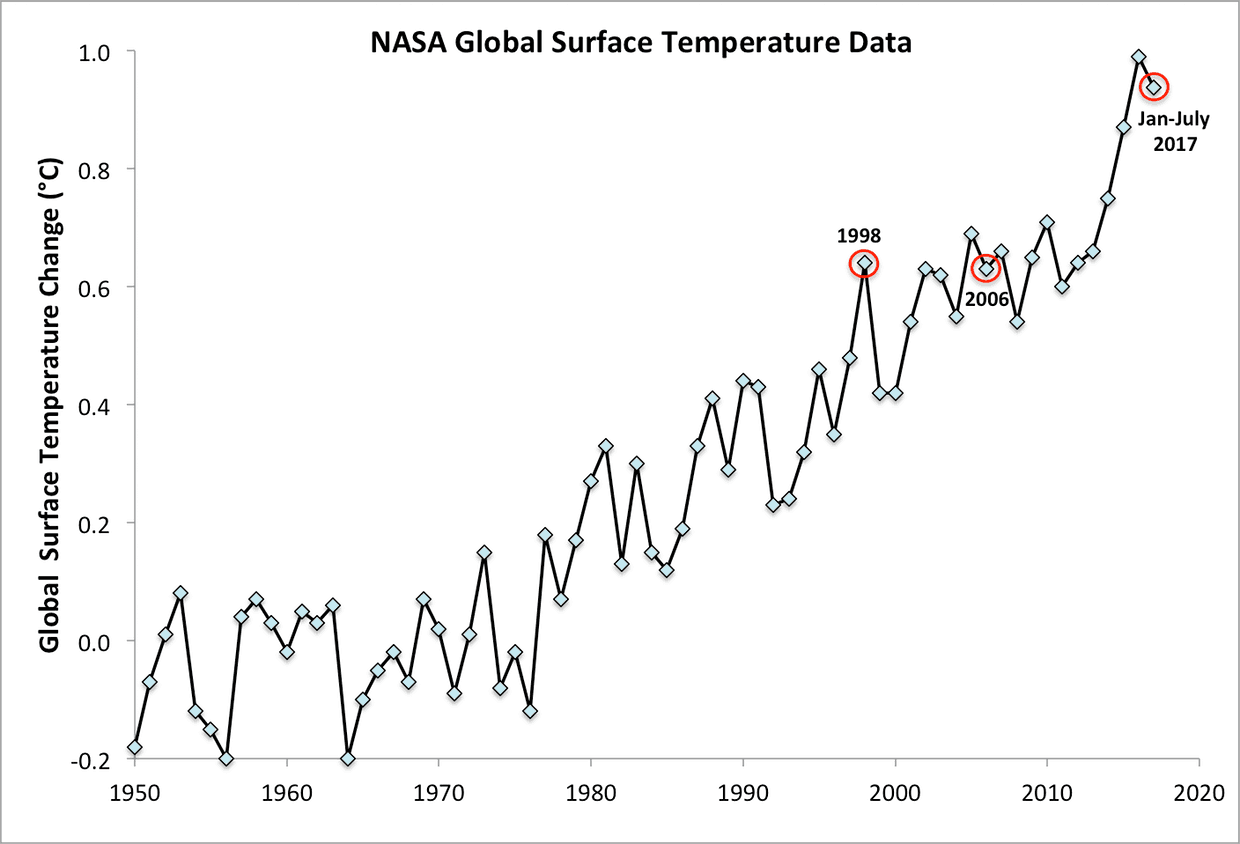
Global average surface temperature data from the NASA Goddard Institute for Space Studies (2017)
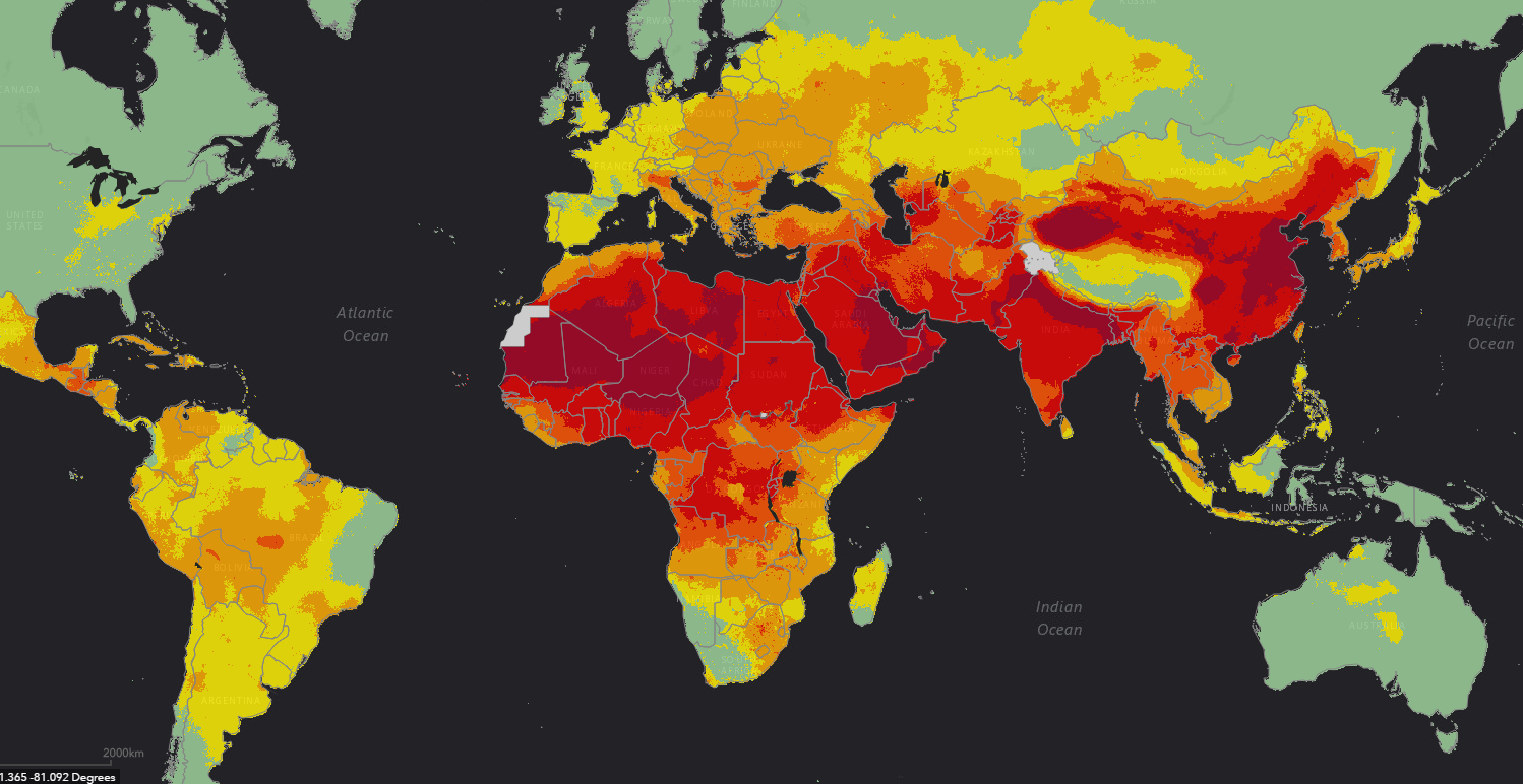
World Air Pollution Map by WHO (2016)
B. Air Pollution
Both short and long-term exposure to ambient air pollution can lead to reduced lung function, respiratory infections and aggravated asthma. According to reports from the World Health Organization (WHO), air pollution is the cause of over 34% of deaths from stroke, lung cancer, and chronic respiratory disease, and 27% of deaths from ischaemic heart disease. The combined effects of ambient (outdoor) and household air pollution cause about 6.5 million premature deaths every year. Today, an estimated 92% of the world’s population lives in areas where air pollution exceeds WHO safety limits (see Figure below).
Pollutants with the strongest evidence for public health concern are particulate matter (PM), ozone (O3), and nitrogen dioxide (NO2). The health risks associated with particulate matter of less than 10 and 2.5 microns in diameter (PM10 and PM2.5) is especially well documented. PM is capable of penetrating deep into lung passageways and entering the bloodstream causing cardiovascular, cerebrovascular and respiratory impacts. In 2013, PM was classified as a cause of lung cancer by WHO’s International Agency for Research on Cancer (IARC). It is also the most widely used indicator to assess the health effects from exposure to ambient air pollution (WHO, 2016).
C. Floods
Floods are one of the greatest environmental threats that can affect millions of people. A flash flood, which can develop in less than few hours, is primarily caused by heavy rainfall and thunderstorms. Extensive rainfall over a long period of time will also lead to flooding of geomorphic low-lying areas. Floods often cause damage to homes and properties, potential loss of lives, and deterioration of health conditions owing to waterborne diseases.
Today weather forecast mostly relies on weather satellites that collect observations globally. While weather forecasts are getting better with more advanced prediction algorithms, we need higher spatial resolution rainfall data in order to measure exactly the amount of precipitation in a specific area. This is because the rainfall and soil characteristics could be very different from place to place. By observing a long-term temporal dataset, it is possible to develop a nationwide framework for flood forecasting (Chang, et. al., 2014; Selvanathan et. al., 2018).
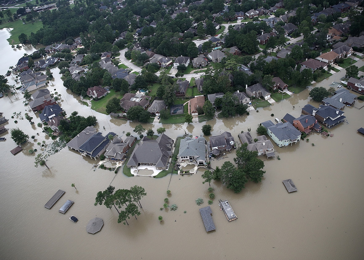
Flooded Residential Areas near Lake Houston following Hurricane Harvey (2017)
[Photo by Win McNamee/Getty Images]
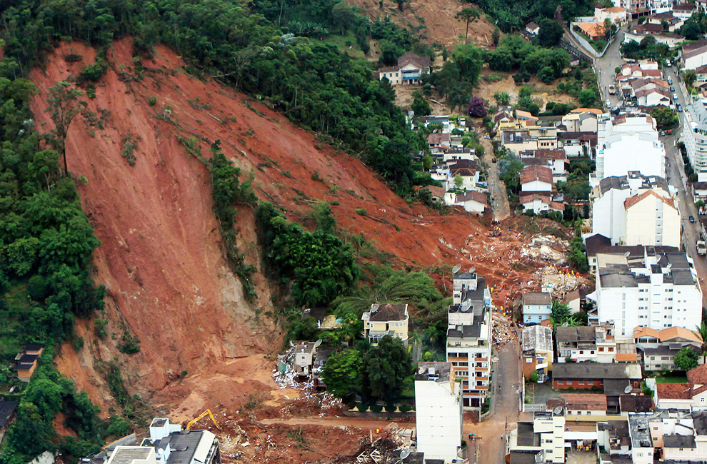
Landslide hits the residential areas in Nova Friburgo, 130 km north of Rio de Janeiro, Brazil (2011)
D. Landslides
Every year, over one million people are exposed to landslide hazards around the world. Due to the recent climate change, it is likely that the decrease of permafrost areas, changes in precipitation patterns and increase of extreme weather events will influence the weather-related mass movement activities. Moreover, the spread of urban settlements and transportation networks into landslide-prone hilly areas is increasing the potential occurrence of landslides, land subsidence and slope failure.
In order to develop an effective early warning system for landslides, it is important to perform a comprehensive assessment about the mechanisms of the landslide, including continuous monitoring of the slope stability, surface runoff, intra ground movement, underground water, and rainfall. The monitoring system may consist of a variety of sensors such as in-place inclinometer, multiple strain gauge, piezometer, tiltmeter, rain gauge, infrared camera, Global Navigation Satellite System (GNSS), LIDAR system and Ground Based Synthetic Aperture Radar (GBSAR) (Koo et. al., 2015, Zhao et. al., 2018).
SO WHAT?
In this article, 4 major environmental threats concerning urban dwellers have been reviewed, namely global warming, air pollution, floods and landslide hazards. Understanding the potential threats of our residential environment is of great importance to ensure our family is well protected. This can be achieved by continuously monitoring the quality of our residential environment through a set of environmental indicators.
Environmental indicators are simple measures in the form of numerical values that track the state of the environment over a period of time. Environmental indicators can be measured and reported at different scales. For example, a city may track the air quality along with the water quality and count the number of rare species of birds to estimate the health of the environment in their area. In another scenario, people living in hilly residential areas may track the variations in rainfall patterns and its impact on slope stability and soil erosion.
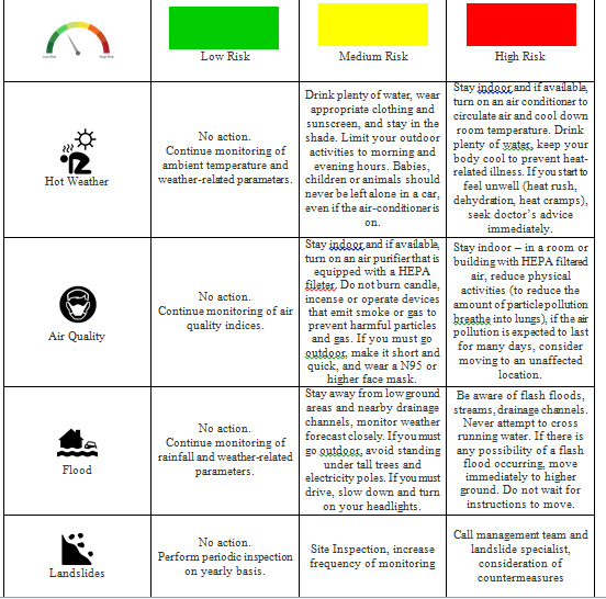
By continuous monitoring these environmental indicators and observing their spatiotemporal changes, a set of criteria can be determined for evaluating the risk level. The risk levels are defined not only by the extent and imminence of the potential hazards but also based on the actions to be taken in accordance with the risk levels. Example of the risk levels and their corresponding actions are depicted in the following figure. The recommended actions are based on the inputs from the experts and the local authorities, and in accordance to standard practices outlined by international bodies such as World Health Organization (WHO), World Meteorological Organization (WMO), and International Consortium on Landslides (ICL).

Voon-Chet KOO is currently a full Professor of Multimedia University. His research interests include remote sensing technologies, signal processing, and embedded system design. With more than 20 years of experience under his belt, he has become a renowned international speaker for various international conferences, seminars and lectures for universities, and public and private agencies in various countries around the world.
In terms of publication, he has successfully published more than 100 papers in refereed journals, international conferences, 2 books, and 10 patents. With his extensive and rich knowledge and experience, it is no wonder that be became the recipient of the inaugural Young Engineer Award by the Institution of Engineers, Malaysia in 2004.